

Andalucia Information
General Area Information - Andalucia
There is a modern road system and the motorways, highways and roads of the region cover more than 24,000 km. There is a high speed train which connects Seville with Madrid in only two and a half hours and other regional rail links connect all of the provincial capitals with several trains daily. There are several large and modern airports supporting the region which are Malaga, Almeria, Sevilla, Gibraltar, Jerez and Granada .
Andalucia is also known as “the bridge between two continents” or “the gateway to Europe”. It is the place where the Atlantic Ocean meets the Mediterranean and the nearest meeting point of Europe and Africa . Fifty percent of Andalucia is mountainous with one-third above 600 meters and 46 peaks are higher than 1,000 meters. The Sierra Nevada range holds the highest mountains with some reaching over 3,400 meters.
Andalucia´s main river, the Guadalquivir , from the Arabic, meaning "Great River", together with its tributary, the Genil, form a valley which constitutes the fundamental geographical axis of Andalucia . From its beginnings in eastern Andalusia, in the Sierra de Cazorla, to its outlet into the sea in the west, next to the marshes of Doñana National Park , the Guadalquivir is a source of life all along its journey across Andalucian territory. As a result of this the land is very fertile so due to this and the climate an abundance of crops, fruits and flowers are grown which are not only used within Spain but exported throughout the world. Farming therefore is one of the most important industries of the region.
Andalusia has been fought over by numerous cultures since the earliest times of civilization each leaving their effect on the culture and architecture of the region. Monuments and relics of these can be found virtually everywhere throughout the region.
The Andalucian coastline stretches for over 900 km and has many ports and marinas. The most important port is Algerciras linking the area with the rest of the shipping world. Fishing also is a major industry of the area.
Andalucian cuisine is divided into two main parts, food based on products from the sea and those based on Serrano mountain area ingredients. Many different ways of preparing fish are used, stews, game dishes, aged pork, vegetables etc form the basic essence of the cuisine. The best known Andalucian dish is gazpacho which is a tomato based cold soup also containing cucumber, pepper, garlic, oil and vinegar. Tapas (small snacks) are very popular. All the above are complimented with the excellent Andalucian wines which are known worldwide.
Bullfighting is an important tradition in Andalucia and bullfights are held in various bullrings throughout Andalucia. They coincide with local festivals and most towns have their own Fiestas where there is dancing and singing to Flamenco music.
The area caters for a wide range of sports. Andalucia has over 60 golf courses including the first desert golf course in Europe. In winter months skiing and snowboarding is very popular in the Sierra Nevada mountains. All other sports and recreational pastimes relating to mountains and countryside are catered for e.g. pony trekking, climbing, horse riding, walking, hang gliding, quad biking, polo, tennis etc and all the water-sports and pastimes are available along the coast e.g. swimming, parasailing, scuba diving, fishing, wind surfing, snorkeling, jet-skiing, sailing etc.
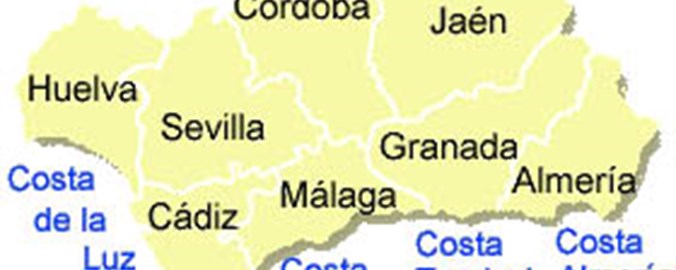
Guides to Coastal Regions in Andalucia
- Costa de la Luz Area Information
- Costa del Sol Area Information
- Costa Tropical Area Information
- Costa Almeria Area Information
- Costa Calida Area Information
- Costa Blanca Area Information
Guides to Inland Regions in Andalucia
- Alora Area Information
- Antequera Area Information
- Archidona Area Information
- Casares Area Information
- Coin Area Information
- Cordoba Area Information
- Granada Area Information
- Iznajar Area Information
- Jaen Area Information
- Loja Area Information
- Ojen Area Information
- Ronda Area Information
- Seville Area Information
- Vinuela Area Information
Alora Area Information
Alora is located 40 km north of Malaga on the road to Antequera. It is a whitewashed village nestled between three rocky spurs topped by the ruins of a magnificent castle, which has an interesting history. Alora's castle was first built by the Phoenicians and subsequently expanded under Roman rule. In the 5th century the castle was virtually destroyed by the Visigoths, only to be rebuilt under the Moors. Remnants of this era still remain, namely in the decorative steel door and the traditional Arab mirador.
Between 1587 and 1593 Alora was home to Cervantes, the author of Don Quixote. Its other claim to fame is that Alora is said to be the birthplace of Malagueño flamenco.
A visit to the village, which consists of a series of very steep slopes and attractive cobbled streets, is well worthwhile. The whitewashed streets are lined with lemon trees and converge on a square on the lowest level, overlooked by the impressive seventeenth century church of La Encarnación which was built during the Catholic era on the site of a former mosque.
From the square, climb to the castle on foot, or go by car, to the cemetery from where you can enjoy the splendid panorama of the Guadalhorce river basin. Among the tombs there is a small Gothic chapel.
Monday is market day when the village becomes a lively mass of stallholders and shoppers. Alora's economy is based on agriculture, in particular the cultivation of tropical fruits, olives and grape vines.
Castanets are just one of the handcrafted items that are made in Alora and are one of the most typical instruments used for the traditional dance of the verdiales.
Alora Fiestas
Alora's main fiesta is the Flamenco festival that is held annually in June. Another popular traditional event is the Romeria de la Virgen de las Flores that takes place in the middle of September and is one of the best places to enjoy, first-hand, the traditional verdiales.
History of Alora
Within the town boundary, at a spot known as Hoyo del Conde, prehistoric remains are to be found.
The Turdetans and, later, the Phoenicians found the Guadalhorce Valley the ideal place to set up colonies to exploit the natural riches of the plains. These would also become strategic locations on the routes leading inland. Phoenician settlers laid the foundations of Alora Castle. In Roman times, it was known as Iluro, while the Arabs called it Alura.
Alora was an important Roman town between 81 and 96 A.D. The town, linked to the Roman region of Betica, was, according to the historian Columela, an important trading center for wheat, barley, honey, wine and oil, all obtained from the area's land. Its prosperity was such that Alora even minted its own coins.
The Vandals conquered it in the 5th century. Remains from the Visigoth period can be found in the fortress located atop Las Torres mount.
During the Moslem occupation, owing to its strategic location -the castle overlooks the whole of the Malaga basin- it was besieged by the Christian kings on numerous occasions. Its reputation as an impregnable fortress gave rise to one of the most beautiful of the frontier ballads: the Ballad of Alora, which refers to the town as "the well besieged" and which can be seen reproduced on a tablet embedded in the castle walls.
The town finally fell into Christian hands on 10 June 1484. Captain Don Luis Fernandez Portocarrero led the attacking troops, who bore the banner of the Catholic Monarchs.
A decree issued by Philip IV in 1628 saw Alora cease to belong to the city of Malaga "for evermore", according to the exact wording of the document. An earthquake left the original church in ruins in 1680, as well as destroying the older districts of the town.
The castle, witness to so many deaths in attempts to capture and defend it, later became the town cemetery.
Antequera Area Information
Antequera dates back nearly 5,000 years in time, beginning with the Bronze Age and the native Iberian's. The timeline can be followed in this fascinating city's profusion of burial mounds, dolmens, Roman baths, a Moorish Castle, Gothic churches, Renaissance fountains and baroque bell towers.
The first sighting of Antequera in the distance is of a typical medieval town, with spires of her many churches silhouetted against the sky. Spread out in the valley below lie rich farmlands irrigated by the Guadalhorce River. For centuries this has been one of Andalucía's most fertile areas, and is currently a leading producer of asparagus, cereals and olives and during summer, its fields turn brilliant yellow with sunflowers.
The town and valley are overlooked by an enormous crag of limestone, 880 meters high, called La Peña de los Enamorados, or "The Lovers' Leap". The name comes from a local legend about an impossible love affair between a young Christian man from Antequera and a beautiful Moorish girl from nearby Archidona, who were driven to the top of the cliff by the Moorish soldiers, where, rather than renounce their love, they chose to hurl themselves into the abyss.
One of Antequera's most impressive sights is its dolmens, located in a park to the west of the town. The most spectacular one is in the Cueva de la Menga. The original Iberian people who created these megalithic mass tombs made of huge slabs of rock date back 5,000 years. There are many dolmens in Andalucía, but none as large as the Cueva de la Menga. When it was excavated in the nineteenth century many hundreds of skeletons were found in its inner chamber.
Other fascinating monuments to be seen
- The recently excavated Roman baths.
- The magnificent Renaissance church of Santa María la Mayor Church.
- The Church of Nuestra Señora del Carmen.
- The 19th century bullring.
- The Arch of the Giants, built in 1585, which leads up to the 13th century Moorish castle.
Archidona Area Information
The town of Archidona lies 943 meters above sea level at the foot of the Sierra de Gracia. During the Roman times, it was known as Arx Domina, then the Arabs modified this to Arxiduna, which is the origin of its present name.
The Sierra de las Grajas has been declared one of the nature reserves of Andalucia. There are two excellent nature trails, the Hoz del Arroyo Marin and the Lagunas (lakes) de Archidona. The area caters for every kind of country sport including trekking, cycling, and mountain climbing. The Nature Reserve, Lagunas de Archidona, is a humid zone, full of saline water, rich in sulphates and of enormous ecological value. From here we can see the Sierra de Gibalto, located in the province of Granada and the Mountains San Jorge and Gorda, in the municipality of Villanueva del Trabuco. There are numerous bird species to be seen, all of which are protected.
Archidona is approximately 40 minutes from Malaga Airport, 50 km from Granada town centre and about 20km from Antequera and there is a good bus service linking all the towns in the area.
The village dates back to prehistoric times, as shown by artifacts linked to the Palaeolithic period. The first major settlers in the area were the Turdulos. The town was an important strategic location for the Carthaginians who reinforced the walls making it a strategic point in the war against the Romans.
Archidona's Salinas (salt mines) or Las Lagunas (lagoons) are located in the north west of Malaga province, inside Archidona's municipality, and in the south west of Estacion de Salinas.
The center of Archidona has many religious buildings mostly dating from the 18th century. One of the oldest is the Hermitage of the Virgen de Gracia, now used as a church, but it was originally a Moorish mosque. It is the only one of its type still in existence in the entire province.
Close to the hermitage are the old castle walls that have been partly restored. Other important churches in the area are the Church of the Nazarene and the Escuelas Pias. The sound of chiming bells is a traditional and common sound to be heard at various times of the day.
The Church of Santa Ana was the first church of the Villa Baja built at the beginning of the 16th century and reconstructed in the 19th century. It is richly decorated and has an interesting triangular tower.
Also well worth visiting is the Convento de las Mínimas. The main square in the town is Plaza de la Victoria and in this square is the Town Hall which was the old granary. It has a stone Baroque entrance, richly decorated and not far away there are a number of caves and petroglyphs, including the Cuevas de Jumandy and the Museo Mundos Amazonicos. One of the museum’s prize exhibits is a large sacred stone scarred with petroglyphs that is thought to be over two thousand years old. Inside the museum is a wide range of artifacts.
The most important festival in Archidona is undoubtedly Holy Week – Semana Santa – a time of processions when statues are carried through the streets.
Casares Area Information
Casares is located half way between the Costa del Sol and the Serrania of Ronda mountains at 410 meters above sea level. It has a population of 3,100 while it sits only nine miles from the hustle and bustle of the coast.
When driving along the coast road, take exit at Km. 147 (between Estepona and Sabinillas) and head inland for 15 km. The scenery is picturesque especially the spectacular view of the village in the distance with its Medieval fortress.
Sightseeing should include the old Roman spa from the Hedionda, the Ferrete caves once inhabited by Paleolithic man, the birthplace of the lawyer Blas Infante (1885-1936) and the ruins of an Arab fort.
Plenty of parking is available on the outskirts of the village, but the roads are steep and narrow, weaving and climbing around the central plaza with its small bars and pretty fountain.
Keep climbing and eventually you will have reached the top of the town of some 1,400 feet above sea level. Here you will find an old fortress here and a derelict church and enjoy picturesque views over the village rooftops. You may also see Peregrine falcons and kestrels and, on a clear day, the African coast with the Rock of Gibraltar looming craggily in the foreground.
On and near the central plaza, there are a number of taverns, one of which has a rooftop terrace. Look out for the statue of "Blas Infante", the founder of Andalucia, who was born in Casares.
Leave Casares on the road winding around the village. When you get to the T junction you can either turn left for Manilva and the coast, or turn right for the next village, Gaucin.
Coin Area Information
Coin is situated in the fertile valley of the Rio Grande, approximately 21 km inland from Marbella. The coastal mountains meet the Guadalhorce Valley between the cork oak and pine woods of Alpujata de Coin.
According to archaeological finds made in the Cerro del Aljibe area of Coin, people have lived here since the first century B.C. Tombs and ceramic pieces found in the Llano de la Virgen area show evidence of a medieval settlement in the area, although we know the Romans stopped off here too.
It was the Moors who began to build the town at it now stands, making Coin one of the most important locations in the region. Abderraman III raised the defensive walls over the remains of the ancient Roman settlement. The Moroccan traveler, Ibn Batuta llamó, called Coin "A beautiful castle with many trees and fruit groves". Coin achieved a high level of economic well-being, due in no small part to the commercial talent of the Jews who traded successfully in wine, olive oil, figs, raisins and almonds.
Coin later became a market town and a transition point for the minerals being quarried 5 km to the south in the Sierra Blanca. Marble from these quarries was certainly used in the construction of the Roman town of Italica, which once stood close to Seville, and was the birthplace in 76AD of the future emperor, Hadrian. The quarrying of marble and the mining of iron ore went on well into the 19th century. During the time of the Visigoths, who supplanted the Romans as rulers of the peninsula, the town lost its luster and appears to have been deserted and left to fall into ruin. By the time the Moors resettled and rebuilt it around 929 AD, virtually all its Roman heritage had been lost and what little was left disappeared in the rebuilding.
One of the most picturesque, yet somber places in Coin is the shrine of Nuestra Señora de Fuensanta, the patron saint of Coin. The beautifully preserved chapel stands on top of a hill beside the ground which is used for the annual pilgrimage. The location and views are magnificent, but the somber note is struck by the now abandoned house which stands close by in a field. In 1893 it was the site of a brutal murder in which the local priest was shot by intruders who believed him to have hidden away a cache of money. The story of the crime and its aftermath were told in Bartolomé Abelenda's book, "The Coin Crime".
Coin is a scenic and untouched Spanish town that has also seen much industry. It is a forward thinking place, while remaining relatively untouched by the international influences to be found on the coast.
Nightlife is lively, with something to suit all tastes, from traditional tapas bars and bodegas and good restaurants to modern air conditioned wine bars to night clubs and discos. It is also lucky enough to have two ferias, or fairs, each year in May and August and these are enjoyed to the full with music that continues each night until 4 or 5 am.
Cordoba Area Information
The province of Cordoba takes up the central northern part of Andalucia and is bordered by the provinces of Malaga, Sevilla, Jaen and Granada. The capital city of the province is also called Cordoba. Cordoba has a population of approximately 800,000 with nearly half living in the capital city itself people.
The weather is hot in the Summer reaching 40C+ and mild in winter as is the rest of the area.
The province is split into several different regions, these being,
Alto Guadiato lies in the north west corner of the province. This area is largely unexplored by foreign tourists and has wonderful countryside and is home to a huge range of wildlife. In the center of the region are the Punte Nuevo and Sierra Bovera reservoirs.
The main towns and villages of the area are Penarroya Pueblo Nuevo which was originally a coal mining town but is now in a state of decay as it was abandoned by a French mining town. The population is around 13,000 but it is not a very attractive town and a layer of soot covers a lot of the abandoned buildings and relics from a time when industry was thriving.
Belmez is another old mining village which again has suffered since being depleted. It has a population of around 4000. Its main attraction is its Moorish Castle which was built on the summit of a dramatic rocky pinnacle and can be reached by a set of steps that have been cut out from the rock face thus making it practically vertical but the views from the top are panoramic.
Espiel clings dramatically to the side of a mountain and has some of the best climbing crabs. The village itself is surrounded by vineyards and to the south of the town is the Puento Nuevo reservoir which is 15 km long. The village has approximately 2,500 inhabitants.
Villaviciosa de Córdoba which is a fairly isolated village with 4,000 inhabitants and is surrounded by countryside and vineyards.
Villaharta is set in lovely countryside with hunting being a popular pastime. It has approximately 600 inhabitants
Obejo is an isolated village reached by winding and twisting mountain roads and has a population of approximately 700. There are breathtaking views and many outdoor pursuits and actives including a nearby golf course. San Benito is the Patron Saint of the Village and te Baile del Patatu (the dance of Patatu) takes place where a sword dance takes place. A mass is held for San Benito inside the church and after the locals dress as swordsmen in bright red waistbands and white shirts and stage a mock battle in the street in time to the music. The climax is when the dancers pretend to chop the head off the master of ceremonies.
Fuente Obejuna is a small town of 6000 inhabitants. In the 15th century the villagers stormed the Palace of a localy tyrannical Lord throwing him out of the window and killing him with lances and swords. His body was then dragged into the main square where the men and women of the village cut it into pieces. Afterwards the inhabitants took responsisbility for the death so no individuals were singled out as murderers. This led to a popular saying “Fuenteovejuna lo hizo” mean Fuenteovejuna did it.
The province of Cordoba is split in two by the River Guadalquivir (which runs westwards towards Sevilla) and this is where the capital city of Cordoba is located. The inner city is on one side and the Campo de la Verdad home to monuments such as the Tower of La Calahorra, Cordoba’s squares, red brick Corredera, Capuchinos with its Cristo de los Faroles, Renaissance Square of the Potro with a fountain and buildings housing the Fine Arts Museum and the Museum of Julio Romero de Torres being just a few.
The river has a large Roman bridge running over the river joining the two sides and it is said the bridge which took 50 years to build, was only finished because the townsfolk sold their jewelry to raise capital. It was believed to have been constructed by the Roman Emperor Augustus and consists of 16 arches. It has undergone many changes over the centuries and suffered many rebellions and battles. Half way over the bridge is a statue of Saint Raphael dating from 1,651. Towns have grown up around the crossings points and the city is now a bustling place with a huge selection of shopping, bars, restaurants and places of historical interest to visit.
In the 11th century Cordoba was one of the most important capitals in Europe. People of different cultures and religions - Jews, Muslims and Christians - were living peacefully together, and important philosophers, scientists and artists emerged from the city.
This city was the capital of the Spanish Muslim dynasty of the Ummayads (756-1031). The Great Mosque of Cordoba – La Mezquita was founded in 785CE. It was added to and expanded over the next 200 years to make it the third largest structure in the Islamic world. The prayer hall which is 23,400 sq m is filled with almost 500 slender columns and superimposed striped archest. Previously the site was a Christian church dedicated to Saint Vincent that had been built by the Visigoths around 500CE and before that when Cordoba was a provincial capital in the Roman Empire the site was occupied by a temple dedicated to Janus, the double-headed god of doorways and gates.
La Campina
La Campina lies to the south of the Capital and is largely countryside consisting of olive groves, vineyards and rolling hills with dozens of pretty villages scattered around. The world famous Montilla wine is produced in this region. The area is steeped in history, remnants of which can be seen everywhere.
Los Pedroches
This area covers the northern tip of the province and has many small towns and villages scattered around. The name Los Pedroches comes from the word “Piedra” which means stone. It borders the provinces of Badajoz in Extremadura and Ciudad Real in Castilla La Mancha and Jaen and is one of the least known areas of Andalucia.
Sierra de Cardena-Montoro Natural Park is situated here and stands in the Sierra Morena which is a 41,212 hectare natural extensión of the Los Pedroches Valley. This park has a wealth of natural resources and the River Yequas flows through the deep ravines across the eastern slopes forming a natural border with the neighbouring Sierra de Andujar Natural Park. Altitudes range between 180 and 828 metres. The climate is dry and humid with high summer temperatures and mild winter ones and is the rainiest area in the province of Cordoba. The area is home to a large range of animals including deer, stag, wildboard, lynx, several varieties of wolk (the latter two under threat of extinction), the wild cat, mongood, genet, common kestrel, long-tailed lizard etc. Birds of prey such as the imperial eagle, the golden eagle, kite, goshawk, sparrowhawk and the black and tawny vultures to name but a few. The river banks are home to the otter, black bird, kingfisher, striped-necked terrapin to name just a few.
La Subbetica
This area consists of hills and countryside and lies in the south east of the province. La Sabbetica covers an area of 159,190 hectars and has a population of approximately 117,000 inhabitants.
The National Park was granted official status as a protected Nature Park in 1988 by the regional Government, the Junta de Andalucia and covers over 31,000 hectares. The main towns of the area are Cabra, Carcabuey, Dona Mencia, Iznajar, Luque, Priego de Cordoba, Rute and Zuheros. The most characteristic feature of this semi-mountainous area is the beautiful shaping of the limestone rock. The steep slopes and rigged crags of the Sierras (hill ranges) look down onto beautiful narrow green valleys.
A few years ago an enormous picturesque reservoir was created at Iznajar and in the Summer when the water drops beautiful sandy beaches emerge with stone seats and bbq’s. The beaches run for miles and miles and more than match the beaches on the Mediterranean coastline but with far fewer people.
The Park is home to a wide variety of animal species including the Wild Cat, Common Fox, Boar, European Hedgehog and the Cabrera Shrew. Bird life includes the Golden Eagle, Griffon, Vulture, Short toed Eagle, Peregrine Falcon (which is the park’s emblem), several species of owl including the Eagle Owl, Common Kestrel, the Black Wheatear, Hoopoe, Cuckoo, Partridges, Rock Bunting and Common and Alpine Swift as well as an assortment of butterflies.
Apart from the city itself this is probably the most popular area of the province for tourists as it is steeped in historic and artistic heritage and archaeological sites.
Most of the area is given to the cultivation of olives and production of olive oil. Andalucia is the largest olive-producing region in Spain and Spain is the largest olive producing country in the world.
Granada Area Information
Granada is the province of Andalucia with the widest range of options for the visitor. There is the coastline to the south and the Sierra Nevada, the highest mountain range in Spain, with excellent winter sports facilites, to the north. Next there are the Alpujarras home to some of the most marvellous natural reserves for rural tourism, and then Granada city itself, former Moorish capital and home of the Alhambra.
Granada has a profusion of historical buildings ranging from Arab palaces to the architectural gems of the Renaissance. Since it was the last Arab kingdom on the peninsula, it is also a symbolic city.
You need time to wander round the streets, through the Albaicin quarter and enjoy the courtyards of the Generalife. Granada needs more than a single day to be explored, as there is a wealth of sights that would be a shame to miss.
Alhambra
The Alhambra is a beautiful ensemble of buildings and gardens. The lush poplar groves provide pleasant shade and the air echoes with the sound of tinkling water. The Koran says that heaven is a garden with running water. From this perspective you could say the Alhambra is an Arabic attempt to create heaven on earth.
The cathedral with its five naves is considered to be the most important Renaissance building in Spain. Built in the transition period of Gothic to Renaissance, it shows elements of the earlier style. Specially remarkable are the main chapel, the Capilla Mayor, the lateral chapels and of course the façade with its sculptures.
Albaicin & Sacromonte
The Albaicín is the old Arabic quarter located on the hill opposite the Alhambra. It is an appealing area of cobblestone streets and white washed houses. In the area there are the remains of an Arab bath complex and the church of San Salvador, originally a Moorish mosque. In the Albaicín you will find some original Moorish houses and a wide range of restaurants.
For centuries gypsies have lived in the caves of Sacromonte. Many of them have been changed into areas for tourists, decorated with ceramics and traditional copper-works. They give regular Flamenco performances.
Sierra Nevada - Skiing
The Sierra Nevada is an exciting winter sports resort. On this page we give you a brief overview of what the area has to offer.
The Sierra Nevada resort is located in the Penibetic mountain range close to Granada. It is centrally situated and easily accessible from the costas - 150 km from the Costa del Sol and 100 km from the Costa Tropical. Three airports - Granada, Málaga and Seville, serve the resort. Many people who associate Spain with sea, sand and sun and are pleasantly surprised to find this wonderful winter sport facility located so near the coast.
The resort is rated as four star for advanced skiers and six star for intermediate skiers. Four star rating is for skiing beginners and for the snowboarding facilities.
The highest road in Europe reaches the Sierra Nevada ski resort, which has a vertical drop of 1,300 meters. It has the best snow and the longest season in the country and the natural snowfall is supplemented by 250 snow canons.
The resort's village, Pradollano is at an altitude of 2,100 meters. Due to its southern location, it is usually warmer than other ski resorts and the air temperature comes as a pleasant surprise to many skiers. Indeed at certain times of the year it is possible to ski in the morning and spend the afternoon on the beach.
High altitude skiing and brilliant sunshine most of the winter, make the Sierra Nevada resort an exciting winter sport venue. In clear weather the views are spectacular and from the top of Veleta peak, skiers can see across the Mediterranean to the Atlas Mountains of Morocco.
There are a good five months of snow in the Sierra Nevada. The resort has 61 km (over 40 miles) of ski slopes with 45 pistes and 6 off-piste routes. There are 2 cable cars, 12 chair lifts and 5 T-bar lifts enabling movement of 32,000 skiers per hour.
The ski resort is open from 9 am to 5 pm although you can ski at night, weekends and bank holidays. Night skiing was introduced in 1994 with lighting along the El Rio slope.
Everything you need can be hired and there are schools for everyone from beginners to experts.
Beginner skiers visiting Sierra Nevada will be pleased with the well groomed green and blue runs on offer here, but the resort is probably best suited for intermediates. There are long red runs - the longest is 6.5 km and goes all the way from the summit of Veleta peak at 3398 m down to the village, with a total of 2,150 m. Advanced skiers will find some challenges´, including a mens downhill world cup run.
Off the slopes there is plenty to do - saunas, gyms, snowmobiles are on hire, as well as sleigh rides, restaurants and plenty of shopping. The après-ski is lively and typically Spanish - that means partying well into the early hours - and there are plenty of bars and clubs in which to party.
Sierra Nevada - Snowboarding
Sport has increased in popularity and the resort, which provides its fans with ideal conditions, is working to promote this discipline. An on-slope half pipe has been built for snowboarders while availability depends on snow conditions. Specialised snowboarding shops and schools are also available within the resort.
In addition to alpine skiing and snowboarding, Sierra Nevada offers many other winter sports including cross-country skiing, artistic skiing (ballet, jumps, moguls), telemark skiing, trekking and adventure skiing.
Iznajar Area Information
This small lakeside town is a charming example of a truly Spanish way of life.
Iznajar is situated near the southerly border of the province of Cordoba and is a natural entrance to the Sierra Subeticas Natural Park. It is a small town with about 6,000 inhabitants.
Iznajar sits on Lake Iznajar - a reservoir created some years ago, which can contain up to 900 million cubic meters of water for domestic consumption.
A bridge has been built across the reservoir near Iznajar to make access easier. Iznajar is the perfect place for anyone wanting to avoid the high cost of purchasing property on the coast while maintaining sea views.
The Valdearenas Beach is on the lake shore and boasts clear, blue water that is safe for even children to swim or play in. The beach disappears during the winter months when the water level is high. But in summer, as the water drops, the beach appears along with the stone tables and barbecues. The lake also provides excellent coarse fishing and competitions are held along its banks.
Originally the village was a prehistoric Iberian settlement, flourishing in the eighth century when Arab settlers built a castle and called it ‘Hins Ashar’. Iznajar gained brief notoriety in 1861 when the town supported an unsuccessful uprising against the monarchy led by Rafael Perez del Alamo.
The ruins of the castle are a key attraction for visitors although they are in a poor state of repair. Parts of the fortified town walls can also be seen in the upper parts of the town.
Another attraction is the Iglesia de Santiago built during the fifteenth and sixteenth centuries, but with a latter addition of a Baroque altar piece. The cemetery next to the church only dates back to 1806.
One of the most interesting districts of Iznajar is the Barrio del Coso, which is a labyrinth of typical whitewashed Andalucian houses. Another interesting visit is to the shrine of the Ermita de la Antigua that was built in the seventeenth century and features a domed vault leading on to an unusual eighteenth century dressing room.
The small municipal museum is dedicated to Iznajar’s agricultural heritage and local customs.
A major pork producing region, Iznajar’s cuisine boasts some of the best pork products to be found in the area. During the February carnival the local sausage is traditionally stuffed with eggs, bread, ham and turkey. Other classic Andalucian dishes are also well represented in Iznajar.
The most important festivals are: Semana Santa, the day of San Marcos on 25 April where all the townsfolk have a mass picnic in the countryside and the annual September fair, or Feria, from 7th to 10th September.
Jaen Area Information
The province of Jaen is situated in Northern Andalucia with its capital city of the same name. It has a rich history with many great monuments and a Moorish castle.
Jaen is famous as the world's leading producer of olives and olive oil. It is the venue for the world's largest trade fair devoted to this Mediterranean crop, which takes place in Jaen city during the first week of October.
The landscape of Jaen province is expansive, unspoiled and very beautiful. The small towns boast numerous magnificent Renaissance buildings - luxurious palaces, richly endowed churches and stately public squares. Some of the towns and villages worth visiting here include Baeza, Ubeda and Alcalá.
The main gateway to the province is from Castilla in the north. The road divides and squeezes through the steep rocky mountain path called Desfiladero de Despeñaperros.
The province of Jaen has many wonderful natural parks, which occupy a large portion of the province. Some of which are:
- Despeñaperros Natural Park - located to the north of the province. It has a natural pathway, which was formed by the river between the Castilian plateau and Andalucia.
- Sierra Magina Natural Park - situated in the south of the region, which has an area of 19,900 hectares.
- Sierras de Andajar Natural Park - situated in the heart of the Sierra Morena mountains and has an area of 73,976 hectares. Here you will find cattle ranches dedicated to the breeding of fighting bulls.
- Sierras de Cazorla - one of the largest protected reserves in Spain and in Europe. It represents almost a fifth of the entire province and is spread amongst 24 municipalities. The nature park possesses 214,000 hectares of land and was declared a Biosphere Reserve in 1983.
These natural, protected areas of the province are the home for numerous species of animals some of which are in danger of extinction. These include the red deer, mouflon, wild boar, Spanish ibex or mountain goat, royal eagles, griffin vultures, and the bearded vulture or “bone-breaker”. In Despenaperros and the Sierra de Andujar there are also numerous communities of lynxes and wolves. The rivers are crystal clear and inhabited by amphibians, reptiles and invertebrates, as well as numerous otter communities.
The Sierra Magina has plant species, which are indigenous to this park and flourish among its highest peaks.
There are three major beauty spots in this province - the Upper Guadalquivir , Laguna Grande (the large lagoon) and Cirobarra Waterfall. The Upper Guadalquivir has a series of small reservoirs that are home to a large community of aquatic birds. The Laguna Grande is found in Gaeza and is the best preserved lagoon in the province. The Cimbarra Waterfalls are in Aldeaquermada where the River Guarrizas gushes through a confined chasm creating a very beautiful setting.
Jaen is known as the capital of the Holy Kingdom due to the Cathedral, which is Renaissance on the inside with a Baroque front. Inside the veil of Veronica and the holy face of Christ are venerated.
Loja Area Information
Loja is situated in the heart of Andalucia on the western side of the province of Granada. It is an attractive town with a population of around 22,000. Loja is connected by a railway station and is only about 35 minutes’ journey from the airports of Granada and Malaga.
The beautiful landscape around Loja consists of rolling hills and fertile fields. The heights of Loja range from 487 meters in the town area to 1,615 meters in the Sierra de Loja mountain range. The town is divided in two because it straddles the banks of the Rio Genil, earning it the name “The Town of Water”. The River Genil has a large number of tributaries which stem from the numerous springs in the area. Due to the abundance of water in the area, the land is extremely fertile and produces many different fruits, cereals, olive oil, pulses and vegetables.
Loja, which was initially grouped around the protecting ancient fortress, has grown to the north and west, climbing along two mountain sides; Hacho, in the north, and Sierra de Loja, in the south.
The climate is mild and fairly dry with temperatures ranging from above 40°C in the summer to -5°C on the coldest days. The prevailing winds blow from the east and west. The east winds are known as Solanos and these are dry and cold in winter but very hot in summer.
The History of Loja
Although much of its artistic heritage has been lost, there are still traces of Loja’s remarkable historical past. The monk Fray Juan Seco, wrote a story about how Loja was founded in 2,163 B.C. by Tubal, a legendary grandson of the biblical Noah. Tricolia, Civis, Illipula Magna or Illipula Laus, among many other names, underline the interest shown by different people in discovering the origins of this town throughout the centuries.
The first historical evidence of human settlements discovered in the town dates back to the XIth century BC, within the final period of the prehistoric cultures of the Bronze Age in the south-eastern area of Andalusia. Later, the commercial contacts with the Phoenician colonies established along the Mediterranean coast of Granada and Malaga began a period of development that reached its peak in the VIIth century BC.
Loja became a remarkable urban settlement under the Islamic power. Medina Lausa, as it was called for the following seven centuries, was to become a military stronghold. It played a key role in the defense of the Vega of Granada, the plain, fertile area along the river valley, from Loja to Granada, which was the natural access to the capital of the Islamic kingdom. Before the town surrendered to the Christian armies in 1486, it already had well defined urban features and important buildings.
The XIXth century saw the historical course of Loja through two particular milestones: the peasants revolt of 1861 and the figure of General Narváez. As a precedent of the revolutionary movements that were to come later in this decade, the peasants revolt, led by Rafael Pérez del Álamo, saw the town occupied by revolting forces for five days. This was an ominous sign of the desperate situation of peasants and share-croppers oppressed by the power of the local gentry. The XXth century brought a relative decrease in the importance of Loja on a provincial level while it saw lower relative growth when compared to other towns in the province of Granada.
Ojen Area Information
The area of Ojen lies between the Sierra Alpujara and the Sierra Blanca (just 15 minutes drive behind Marbella), its highlight being El Juanar Valley, an area of immense natural beauty.
The village itself is surrounded by orchards of avocado, olive and citrus trees. It retains its original Arabic layout, with houses built on different levels to accommodate the mountainside on which they are built. Ojen is widely considered to be one of the most beautiful villages in the province.
The village houses the Malaga Wine Museum, a pleasant place for visitors to stop off in. Friendly staff will explain the local wines on offer and a relaxed tasting with a traditional tapa is a must. There is also a shop selling wine and related curios as well locally produced handicrafts.
Ojen boasts some traditional ventas and bodegas in which some excellent traditional Spanish food and drink are served.
Situated within close proximity to the amenities to be found in Marbella, Ojen itself has its own school, doctor and other local amenities, including an open air swimming pool, making it ideal for those moving to or spending long periods of time in the village.
History of Ojen
Ojen dates back to the Andalusi-Arabic period, when it was known as Oxen or Hoxan, meaning "rugged place". Records tell us that in front of the village walls (now gone) Abderraman III's troops fought with the muladíes (Christian converts to Islam) led by Omar Ben Hafsun in rebellion against the dominance of the Emirate of Cordoba. Having defeated the muladíes, Caliph Abderraman III ordered the building of a mosque as proof of Moslem supremacy over Christian converts.
Following the village's capture by the Catholic Monarchs, one hundred moriscos (Moslem converts to Christianity) and four Christians remained, all of whom were devoted to agricultural tasks. However, by the mid 16th century, the moriscos had grown tired of the abusive taxes which they were obliged to pay and, encouraged by the inhabitants of Istan, set fire to the village and its church and fled to the Alpujarra region. By the end of the same century, the village was practically abandoned.
In 1807 it was declared an independent village by Charles IV.
Ronda Area Information
The ancient, fortified, mountain top town of Ronda is situated at 750m in the Serrania de Ronda. It is a wonderful aristocratic town that has been described as having equal amounts of art, history and beauty.
The best know attraction is the El Tajo or The Gorge, which is 120m deep, and separates the old part of the town from the new. Three bridges, the most famous of which is the Puente Nuevo or New Bridge, span the gorge. Despite its name, the Puente Nuevo was built between 1755 and 1793. Many people have died as a result of falling or being thrown from the bridge into the gorge below. The first recorded death was that of the architect who fell whilst inspecting part of the building works.
The area surrounding Ronda was notorious bandit country and it is said that many of the bandits’ enemies were thrown from the bridge. Certainly at the time of the civil war, hundreds of victims from both sides of the conflict were hurled to their death.
On either side of the gorge, houses and hotels cling to the cliffs and look as if the slightest push would plunge them into its depths.
The old part of the town retains its Moorish influence, with narrow, rough streets and a number of interesting places to see, including:
- The Banos Arabes (Arabian Baths) the remains of this 13th century building can be visited.
- The Palacio de Mondragon was once the private home of one of the visitors to Charles III.
- The Palacio del Marques de Salvatierra, a Renaissance style mansion, still privately inhabited but open for guided tours.
- The Casa del Rey Moro, meaning House of the Moorish King. This is a misnomer as the house was built in the eighteenth century long after this part of Spain was recaptured from the Moors, however the foundations are believed to be Moorish. Unfortunately the house is closed to the public, but is well worth a visit to see the outside and the gardens.
The new part of the town is known as the Mercadillo (Market) as it was where traders, who were not allowed inside the city walls, set up their market stalls. The most notable building in this part of the town is the bullring which is believed to be the oldest in Spain.
The Plaza de Toros is open to the public and contains a museum of bullfighting. Bullfighting in Ronda only takes place once or twice a year. There is a festival devoted to Pedro Romero, one of the greatest bullfighters of all time who, in his career killed 5,600 bulls at Ronda. The bullring is now owned by another famous bullfighter, Antonio Ordoñez, on whose nearby ranch the ashes of Orson Welles were scattered.
Seville Area Information
Everything associated with Spain and Andalusia comes together in Seville with its orange trees, flower filled patios, Flamenco and castanet rattling gypsy culture. It has been said that if you can only visit two Spanish cities, then Seville should be one of them.
Seville was where Christopher Columbus landed on his return from discovering America and he is reputed to be buried under the cathedral. It was also the setting for both Mozart's Don Juan and Bizet´s Carmen operas. Carmen was, in fact, a tobacco girl who rolled cigars on her thighs in the tobacco factory which can still be seen today. The factory is the second largest building in Spain and is now part of the Seville University buildings.
The major sights in the city are the Cathedral, the Giralda Tower, the Alcazar Palace with its magnificent gardens, the Barrio de Santa Cruz or old Jewish quarter and the Parque Maria Luisa. The Barrio de Santa Cruz is the most colourful part of the city with its winding, Medieval streets, fantastic tapas bars and tiny plazas all shaded by flower filled patios and balconies. A wonderful modern theme park is located upon a 540 acre island in the river.
The Cathedral is the largest Gothic building in the world and the third largest church in Europe. Built on the site of an ancient mosque building started in the 1400's and completed centuries later. Next to the Cathedral is the Giralda Tower and, just as Big Ben symbolizes London, this Moorish tower does the same for Seville. It was erected as a minaret in the 12th century when Seville was under Moorish rule and has since been added to. Most unusually there are no steps to the top, instead there is just an endless ramp winding its way up inside the tower.
Vinuela Area Information
Lake Vinuela lies within the heart of some of Andalucia's most spectactular scenery in Axarquia. A man-made reservoir which, as well as serving the purpose of providing thousands of homes with water, in an aesthetic sense has become an important part of the local landscape. Before the area was flooded to create the reservoir, many sites were excavated providing finds from Neolithic and Roman eras.
As the lake is a reservoir, no motor boats are allowed so simple sailing boats and canoes are the only vessels to disturb the flat calm of the surface. Around the southern end of the lake picnic tables and barbecues have been scattered, all with fantastic views of the water and mountains behind.
The lake took its name from the nearby village of Vinuela which nestles in a valley laden with olive groves, vines and cereal crops.
Two tributaries of the River Velez, the Guaro and the Seco, run through the municipality. Guaro River was dammed to create the reservoir that now holds 170 million cubic meters of water.