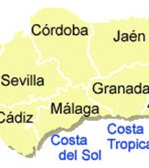

Costa Tropical Information
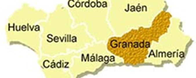
The Costa Tropical is the relatively new name for the stretch of coastline in the province of Granada. It lies between the Costa del Sol and the Costa Almeria and was previously part of the Costa del Sol. The airports at Almería, Granada and Málaga serve the area. Use the links below to see information on the specific regions
- Almunecar Area Information
- Frigiliana Area Information
- La Herradura Area Information
- Motril Area Information
- Nerja Area Information
- Torrox Area Information
The name Costa Tropical comes from the sub-tropical climate that favours the cultivation of exotic crops such as avocados and mangos. With warm winters and long hot summers, the average year round temperature is 20°C.
It is a picturesque region with mountains running down to the sea. The coastline stretches for 19 km with no less than 26 different beaches. Some of these beaches have wide stretches of sand, others are delightful sheltered coves or small rocky bays only accessible by steep tracks.
The Tropical Coast has a wealth of history to offer the visitor and far from being overcrowded with tourists, has managed to retain its Spanish character. Dotted along the coast are towers and fortresses that once served as watch posts during the Arab occupation.
Almuñecar, the capital town of the Costa Tropical, is the most Spanish of all the towns in the region and many Spaniards spend their summer holidays here. The Phoenicians, who named it Sexi, founded the town 3,000 years ago and are one civilisation among the many that have given the town its rich, historical heritage.
Salobreña is a picturesque white village, topped by a Moorish castle, that clings to a large rock and spills down towards the shore. The last sugar cane plantations in Europe surround the town. It is 45 minutes from Granada and about one hour from the Sierra Nevada mountains. It has 6,000 years of history including a 10th century Moorish castle.
Almunecar Area Information
Almuñecar is situated on a relatively unknown stretch of southern coastline called the Costa Tropical in the province of Granada. It lies between Costa del Sol to the west and Costa Almeria to the east and has a population of about 25,000.
A mere 40 minute drive to Granada and only 90 km from Malaga airport, Almuñecar easily accessible while enjoying a peaceful location.
The economy of the area used to be based on agriculture and fishing but today tourism has taken over. Water sports of all types are available and diving is particularly popular due to the wonderful underwater scenery.
Positioned between the Rio Verde and Rio Seco river estuaries, Almuñecar stands on a promontory separating two alluvial flood plains. The shorelines of these plains form the town’s main beaches of Puerta del Mar on the east, and Playa San Cristobal to the west. Cliffs, that support the Arab citadel, cross these beaches and several large rock formations lead out to sea, creating interesting coves.
The largest of these rock formations, El Penon del Santo, once held an ancient shrine and was accessed from the castle by a bridge. There is now a large cross on top, illuminated at night. The layout of the old part of town is typically Moorish with steep winding streets leading from the central square, the Plaza de la Constitucion, where the town hall stands, towards the castle and highest old quarter called Barrio San Miguel.
The largest of the rock formations, El Peñon del Santo, once held an ancient shrine and was accessed from the castle by a bridge. There is now a large cross on top that is illuminated at night.
The old part of town is typically Moorish with steep winding streets leading from the central square, the Plaza de la Constitucion, towards the castle and highest old quarter called Barrio San Miguel.
The Castillo de San Miguel was originally a Roman castle in the 1st century BC. It was rebuilt by Moors in the 10th century and became an impressive fortress.
Other attractions in Almuñecar
The Castle Museum - housed in the Castillo de San Miguel.
The Archaeological Museum - not far from the castle. It is located in the cellars of a Roman construction known as the Cave of the Seven Palaces. The museum houses some interesting finds from the area, including a 3,500 year old Egyptian vase.
The Parque de Majuelo - close to the castle, with shady botanical gardens and a colourful display of exotic plants. In the center of the park there are remains of Roman fish salting pits.
The Aqueduct - 7 kilometers in length, built by Romans, much of which still stands.
Excavations near the new Plaza Mayor - recent finds of Roman water channels and hot baths.
Frigiliana Area Information
Frigiliana is located in the foothills of the Sierra de Enmedio, a southern extension of the Almijara mountain range. It is an extremely pretty village which has received several awards for conservation and beauty. The town is surrounded by spectacular countryside as well as wonderful sea views and good access to the coast. It lies at an altitude of 435 meters within the area of Axarquia, on the scenic sun and wine route and has a population of 2,200.
It is easy to get to Frigiliana, which is only 56 km from Malaga along the coast road. At Nerja the turn off into the hills is a further 7 km through magnificent mountain scenery. A regular daily bus route runs from Nerja to Frigiliana.
There are two distinctive parts to Frigiliana: one of Moorish and Medieval origin and the other modern. The modern side has copied the architectural style of the old village, but offers a more comfortable lifestyle. Between the two districts there are two interesting buildings; the former granary built in 1767 and a 16th century Renaissance palace that is now a molasses factory.
In the old sector, the narrow, winding streets are full of interesting shops and bars. Twelve mosaics by the artist Pilar Garcia Millan depict the village's history. At the highest point of the town there are remains of a Moorish castle. The parish church of San Antonio was built in the 16th century and houses three excellent 17th century paintings. Treasure containing precious metals is exhibited in the sacristy.
Settlement of the area originated in prehistoric times and archaeological sites date back to 3000-1500 BC. Phoenician and Roman remains have also been unearthed.
The River Higuerón irrigates the area, which produces sub-tropical fruits and vegetables and the drier slopes grow olives and grapes. The grapes are used to make the excellent sweet and dry wines of the area.
La Herradura Area Information
La Herradura is situated 60 kilometres to the east of Malaga. It lies at the eastern end of the Costa del Sol and has a two kilometre stretch of beach within a beautiful bay from which the town takes its name (herradura meaning horseshoe).
Golf courses within easy reach along the coast are 30 kilometers to the west at Torre del Mar or 25 kilometers to the east at Motril.
In the old town is entwined with narrow streets that climb a gentle hill from the beach, bordered by whitewashed houses and leading to flower filled plazas. Strict regulations in La Herradura prevent high rise construction in the newer developments to the east of the old town.
Rugged hills thrust up steeply from valley floors or plunge into the sea. Seasonal torrents, often swollen by melting snows, cut jagged ravines deep into the landscape. Once forested hillsides, now provide a scanty foothold for almond, olive and the hardy carob. Small villages and farming communities have developed in sheltered valleys or simply cling like limpets to the hillsides.
Above everything towers the grand Sierra Nevada. These mountains, which boast among them the highest peak in mainland Spain, form a natural weather break protecting the Granada coastline from the worst influences of the European winters, while Africa, to the south, helps buffer the harsh effects of both the Mediterranean and Atlantic weather. As a result, the area has an extraordinarily benign subtropical climate, which can be seen in the variety of exotic products to be found in the local markets, especially the different fruits.
Along the 19 km of local coastline, visitors can choose from a large variety of beaches and small coves, ranging from fine sand to shingle. Water sports are very popular and there are numerous businesses offering different types of courses and equipment hire. Underwater scenery is widely considered to be more beautiful here than anywhere else along the southern coast.
Motril Area Information
Motril is the largest town on the Costa Tropical with 50,000 inhabitants and is situated just off the main coast road between Almeria and Malaga. At only a forty-minute drive from Granada, Motril is an ideal point from which to explore the countryside, sea and town of Granada.
Mainly a commercial city, Motril is the Costa's main shopping center with a hypermarket on the outskirts of the town and many supermarkets, bars, restaurants and nightclubs in and around the town center. The marina provides a wealth of water sports and boat excursions including trips to Morocco.
Motril has a long history, which is illustrated by the number of monuments and churches in the town. Among them is the Museum of Sugar that is devoted to the history of sugar cane which was the main industry of the city for centuries.
The old quarter is a typical example of Spanish Arab architecture:
Town Hall – Built in 1631 in baroque style. There is a mudéjar coffered ceiling in the main entrance hall and the assembly hall. Casa de las Palmas – 16C sugar mill Sanctuary of Nuestra Señora de la Cabeza stands on a hill overlooking the Park of the people of the Americas . This baroque shrine was built on the former Moorish palace of Aixa.
The town's coastal strip includes two main beaches - the busiest being Playa Poniente, which is well served with tourist facilities, and the quieter Playa Granada.
There are also many sheltered coves, rocky inlets and impressive cliff faces along this stretch of coastline making it popular with divers, snorkelers and sailors.
Nerja Area Information
Nerja is on the coast some 50 km from Malaga on the N340 coastal highway and marks the eastern tip of the Costa del Sol. Once a sleepy fishing village, the town now has a population of over 12,000.
Powdery sand and sparkling clear water are the features of Nerja’s 16 km of beaches. All major water sports are available here including water skiing, scuba diving and sailing.
Flanked by a dramatic mountain range, Sierra Almijara to the east, the town has managed to avoid being blighted by the concrete high-rise building that has been the inevitable result of the tourist boom in some other coastal resorts.
The old quarter of the town is still virtually unchanged with narrow, winding streets, whitewashed houses with wrought iron terraces overflowing with geraniums and sometimes a canary can be heard singing from one of these.
The heart of Nerja is its spectacular Balcon de Europa, the "Balcony of Europe", a magnificent promenade along the edge of a towering cliff. Once the site of the great Moorish castle, it has sweeping panoramic views of the Mediterranean and small coves and beaches below, set against an awesome backdrop of hazy mountains.
Nerja cuisine includes several specialities including De La Concella (red mullet) and pescaito frito (fried hake). There are plenty of restaurants and cafes to choose from and you can find everything ranging from top international cuisine to the ubiquitous sausage, eggs and chips.
The visitor can hire a horse drawn carriage to explore the most romantic corners of the town. Nerja’s monuments include the 17th century Church of El Salvador in a style that is a charming mixture of baroque and Moorish. The beautiful gardens of Capistrana Playa that descend to Burriana Beach are worth a visit.
However, Nerja’s most spectacular attraction is undoubtedly its fascinating caves, located just three kilometres from the centre of town. They include archaeological treasures such as paintings over 20,000 years old and other pre-historic remains. One of the enormous natural caverns has been transformed into a concert hall, where many performances are staged during the summer.
Torrox Area Information
Torrox is a very white town with 12000 inhabitants. It is 45 km from Malaga and 20 from Velez. It is 126 m. high and sheltered from the Northern winds by the mountains of Tejeda. Torrox is proud of its denomination as the place with the best climate in Europe. This is a privileged spot to have a rest, as well as to enjoy its mountains and its beaches and of course to try some of its gastronomic specialities, such as "espetos of sardines", "migas cortijeras", fresh anchovies or "papas a lo pobre", enhancing the taste of any of them with the famous local wines.
Torrox has a population of 1,2000 and is 45 km from Malaga and 20 km from Velez. At an altitude of 126 m it is sheltered from the northern winds by the Tejeda Mountains.
Torrox is divided into three areas:
Torrox Pueblo has retained its white Moorish village structure with attractive narrow streets and a main square that is a lively meeting place. Much of the town has beautiful views down to the coast.
There was once a Moorish castle on top of the hill on which the town stands where, it is claimed, King Almanzor was born in the 10th century. During the Moorish occupation, Torrox prospered in agriculture and in the silk trade. 16th century buildings include the Mudejar style church of Nuestra Señora de la Encarnación and the Shrine and Convent of the Virgen de las Nieves. Interesting civil works include the 18th century Hospital of San José and the 19th century Sugar Factory.
Torrox Costa is one of only two towns along the coast of Axarquia that has high rise apartment blocks along its central coastal stretch. This is compensated for by two splendid maritime promenades with attractive restaurants and bars and 9 kilometers of wide sandy beaches. On either side of the main area, you will find more rustic, low rise buildings and bamboo fringed beaches.
El Morche, on the coast to the west of Torrox Costa, is a small, unspoiled seaside village. To the east of the main town, alongside the lighthouse, the new 'Balconde Torrox' has been constructed as a lookout to the sea and headlands. There is a transparent floor through which Roman ruins can be seen.
Phoenician remains on the coast testify to the long history of settlement in the area but Torrox was an important factory town during the Roman era. The extensive ruins have been conserved on the coast beside the lighthouse. These include: a necropolis, restored thermal baths, ovens used in the manufacture of ceramics, houses, the luxury villa Clavicum built in the 1st century and troughs used for the preparation of fish paste (garum).
The River Torrox irrigates the area supplying water for the cultivation of sub-tropical and greenhouse fruits on the coast and vineyards and olive trees inland.
The gastronomic specialities of the area of Torrox are: espetos de sardines, migas cortijeras, fresh anchovies or papas a lo pobre. Enhance the taste of these delicious dishes with the famous local wines.